ICAO Drone Enable: “First European UTM/U-spaces planned for Q1 2024”
By Jenny Beechener
On a quest to identify deployment progress of Uncrewed Traffic Management (UTM) systems capable of supporting beyond visual line of sight (BVLOS) drone operations, ICAO’s Drone Enable 2023 webinar discussing UTM deployment best practices and lessons learned held on 14 November heard promising results from air navigation service providers including latest developments in Belgium, Canada and the UK.
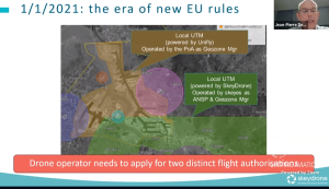
Among early movers, Belgium predicts its first UTM implementation will be operational in Q1 24, building on lessons learned since skeyes’ launched the national Droneguide platform in 2019. “New European rules since January 2021 encouraged the development of geozones,” said Jean-Pierre De Muyt, regulatory expert for UTM service provider SkeyDrone. “This is good for geozone managers such as the Port of Antwerp and skeyes who manage individual projects in controlled airspace. However, this leads to compliance issues when areas overlap and drone operators have to log into different UTM systems to obtain flight authorization.” (Fig 1)
The Belgium-Netherland U-space reference design implementation project – BURDI – is designed to integrate multiple and complex UAS missions to overcome these limitations. The solution uses U-space services such as UAS flight authorisation, geo-awareness, network identification and traffic information, in addition to e-conspicuity by airspace users. Working with the Belgian regulator, SkeyDrone is completing the airspace risk assessment for Antwerp, earmarked as the first BURDI deployment project.
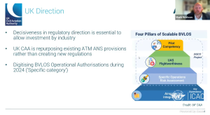
The UK also plans to make BVLOS operations easier from 2024, when air navigation service provider NATS will introduce digital authorisation. “The average processing time with the current manual system is 70 days,” said Mark Watson, Head of UTM Service Integration. “Speeding up BVLOS authorisations is important for industry growth.” NATS is working with the regulator on four main areas to support scalable BVLOS operations (Fig 2): Pilot competency, UAS flight worthiness; Specific Operations Risk Assessment (SORA); and airspace integration. To achieve electronic conspicuity, NATS expects to develop transponder mandatory zones, he adds.
The UK Civil Aviation Authority (CAA) is funding sandbox activity using re-purposed Temporary Reserved Areas (TRA) to test solutions co-developed with industry to help develop policy around BVLOS operations as part of the UK wider Airspace Modernisation Strategy. Further measures include development of digital flight rules to compliment visual flight rules and instrument flight rules used today.
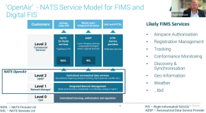
Central to the UK’s approach is the “single point of truth, bringing together aeronautical information, traffic information and flight information in a strategy that will digitise lower airspace traffic management services,” said Mark Watson. NATS’ aeronautical data exchange platform OpenAir, launched in September 2023, provides the foundation to support these services and enable uncrewed aircraft to be integrated safely alongside commercial and general aviation (Fig 3).
Another country edging closer to BVLOS operations, Nav Canada announced it will publish a Concept of Operations (ConOps) in the coming weeks for BVLOS remotely piloted aerial systems (RPAS) Traffic Management (RTM) in low-risk airspace. Transport Canada has just completed a consultation process on a regulatory framework it plans to introduce in 2025 to enable drones to operate in less-populated areas.
“We have a safety-critical framework for VLOS operations since mid-2021, rolled out at all air traffic service units across Canada, to provide aeronautical information, flight planning and digital authorisation in controlled airspace,” said Alan Chapman, Nav Canada Director of RPAS Traffic Management. “We have over 40,000 users, rising about 10% every year.” The single solution enabled Canada to advance quickly, for example benefiting drone applications over this large land mass. “However, building a system around regulations while not constraining its use is a challenge. For example, we applied the existing safety management system (SMS) to new entrants, using the same metrics and methods. We are following with interest Federal Aviation Administration (FAA) SMS adjustment proposals.”
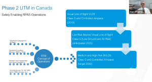
With drone operations growing, including on-airport, Nav Canada plans greater integration of its digital platform, adding RTM data to controller screens rather than using separate monitors. Developing this technology is part of Nav Canada’s next development phase coinciding with publication of the ConOps (Fig 4). Based on Nav Canada’s operational mandate, Alan Chapman anticipates a heavily centralised set of services to support RTM service providers in Canada. Nevertheless, RTM service providers will still provide the front end for operators and pilots, with many developments and findings coming from Europe’s U-space research programme informing Canada’s decision making.
